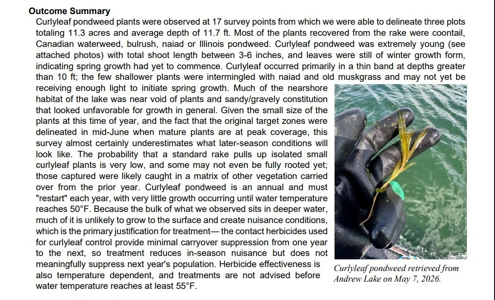
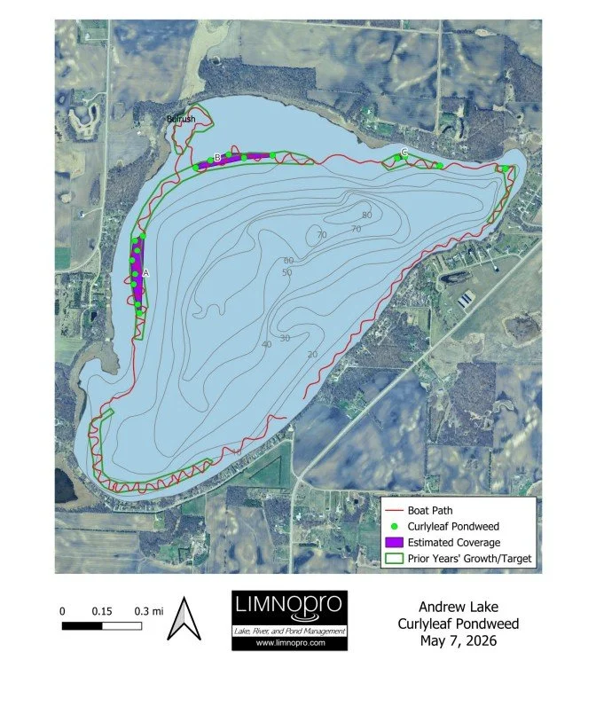
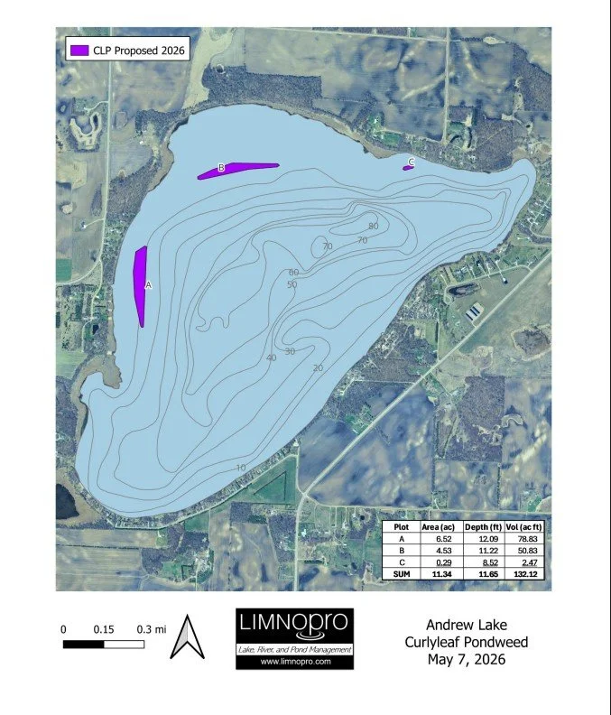
2026 CLP Survey from LimnoPro
Lake Andrew Outlet Survey
Lake Andrew Run-out Elevation Analysis 8 January, 2026
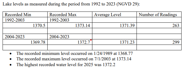
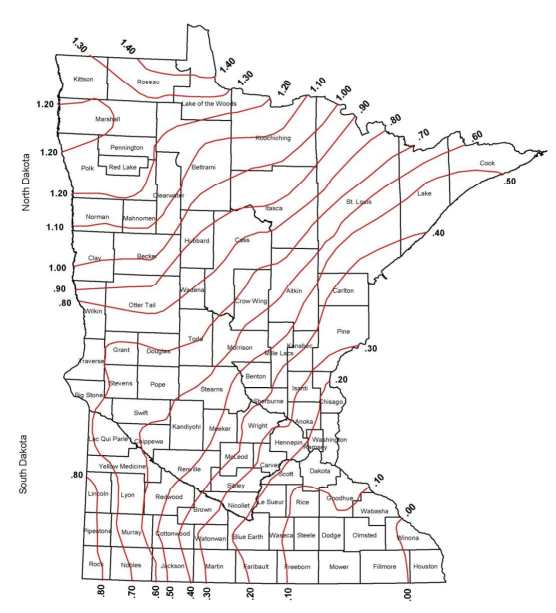
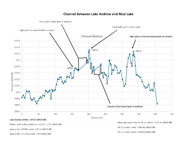
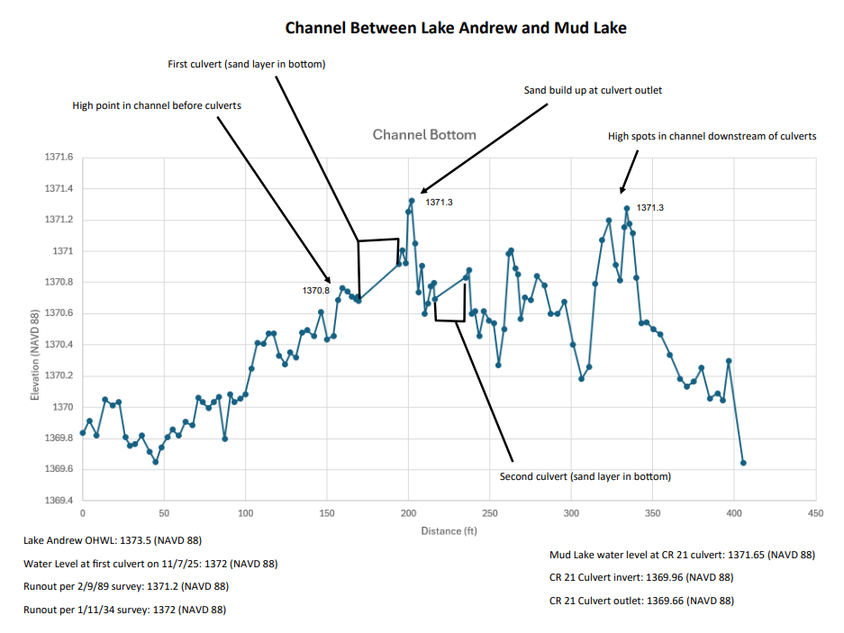
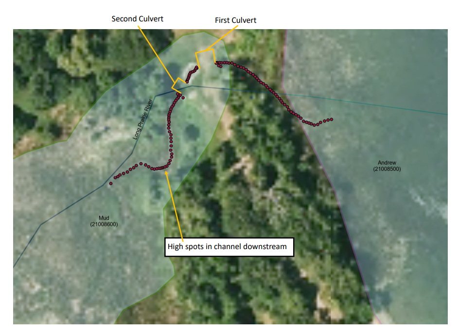
Issue: The Lake Andrew Association is devoted to listening to resident’s concerns and consequently trying to resolve them. One issue that remains in question is the run out elevation of the lake. The lakeside culvert elevation, determined by a survey company in April 2023, is 1370.0 National Geodetic Vertical Datum [NGVD (29)]. The run out elevation listed on the DNR website is 1370.6 (29). Of interest, Lake Andrew is the top of the watershed draining through Mud Lake into the chain of lakes and exiting Lake Carlos into the Long Prairie River. Research: The research and discovery effort yielded the following: the 1989 survey of the outlet, the permit issued by the DNR to install the culverts in 2004, the LAA contracted surveyor’s notes from April 2023, Jerry Mahoney’s findings, the recent DNR survey of the culvert area on November 7th, 2025 and discussions with the DNR hydrologist assigned to Lake Andrew. Analysis: The explanation by the DNR is supported by the restrictions and guidance within the permit. The permit states the culvert will be placed at an elevation below 1370.6 (29): recommending 9 to 12 inches below 1370.6 or an elevation between 1369.85(29) to 1369.6 (29). The rationale to set the culvert below the existing run out elevation is that over time sediment will collect in the base of a circular channel. There are two culverts in series located at the channel between Lake Andrew and Mud Lake. The distance from the outflow of the first culvert to the inflow of the second is approximately 20-25 feet. The channel between the culverts consists of a sandy bottom shouldered with rock. The discussions with the DNR detailed that the run out elevation is based on the elevation of the natural channel or a control point such as a culvert. Further exploration determined the run out elevation can vary from year to year. Natural occurrences such as ice heaves, wave action and excessive flow can alter the height of the natural channel either increasing or decreasing the run out elevation. For instance, the run out elevation determined by the 1989 survey is 1370.5 (29). Conclusion: The comprehensive DNR survey conducted in November 2025, established elevations at over 110 points upstream, downstream and in-between the two culverts. The survey used the NAVD 88 datum to determine elevations. In our area the 88 datum is .7ft higher than the NGVD 29 datum. The run out elevation, as determined by the 7 November survey, is 1371.3 NAVD 88 or 1370.6 NGVD 29. That elevation occurs shortly downstream of the first culvert on a high point in the sandy channel bottom. There is another point in the channel to Mud Lake, downstream of the second culvert that is also at the elevation of 1371.3 NAVD 88 or 1370.6 NGVD 29. The 2025 survey results are included later in the document. Numerous other factors can alter lake levels. The evaporation rates vary based on the temperature, humidity and wind action. Evaporation rates can exceed over an inch per week, given the right conditions. The lake is also fed by a number of springs and small streams. The drainage into the lake can be altered by current and previous years precipitation. Other factors would include the number of irrigation systems feeding off aquifers that feed the springs. Also, changes to areas surrounding the streams that feed the lake such as: crop cover, road and culvert altercations, drainage ditches and changes to pervious and impervious soils. And the lake can experience sub-surface gains or losses from / to aquifers and fissures. By a significant degree, the two biggest factors affecting lake levels are precipitation and evaporation! Supporting Information Elevation Datums: The elevation standards can get somewhat confusing if not clearly stated. The new datum, NAVD 88 for our area is .7ft higher than the previous datum, NGVD 29. See DNR conversion figure below. • To equate the elevation, subtract .7 ft from the NAVD 88 elevations. • To convert fractional feet into inches just multiply by 12 (.7ft x 12 in/ft = 8.4 in). NGVD 29 (National Geodetic Vertical Datum of 1929) is the older, less accurate elevation system replaced by NAVD 88 (North American Vertical Datum of 1988), a more precise standard incorporating modern techniques like GPS and gravity measurements, with differences varying by location, typically around a foot or more higher in NAVD 88 than NGVD 29, requiring specific conversion tools for accurate transitions. Additional Analysis: The DNR completed a Lake Andrew surface water level analysis in November of 2023. The analysis compared two time periods, one from 1992 to 2003 and the other from 2004 to 2023. The first time period analyzed the lake level prior to the insertion of the culverts and the second the 19 years following the installation. The analysis indicated there has been a minor change in average water levels after the installation of the culverts. The average change amounted to less than two inches. The minimum water level measurement, after the culvert installation, is 8 ½ inches lower than the minimum from 1992 to 2004. Further analysis of precipitation levels for the two time periods revealed a significant difference: the 1992 to 2004 period had remarkably high precipitation amounts.